Jupiter's homes sit in two main ZIP codes and two high school zones. Our guide to 10 areas from the town's own map: schools, home values, roads.
Last checked Oct. 9, 2026. Sources: the Town of Jupiter’s neighborhoods map, Abacoa page, Neighborhood Services page, Community Redevelopment Plan and GIS layers, Palm Beach County’s school zone open data, the Florida Department of Education’s 2026 school grades, the Zillow Home Value Index, the U.S. Census Bureau and OpenStreetMap.
Jupiter had 61,883 residents in the Census Bureau’s 2020-2024 American Community Survey (QuickFacts). The town grew out from the Jupiter Inlet, where the Loxahatchee River meets the Atlantic, and its homes now stretch west past I-95. The Town of Jupiter’s own neighborhoods map names more than 150 of them.
A few roads organize the town. Indiantown Road (State Road 706) crosses it from west to east, with interchanges at I-95 (exit 87) and Florida’s Turnpike (exit 116). Military Trail and Central Boulevard run north to south through the middle, U.S. 1 and Alternate A1A run near the water, and A1A follows the beach. Donald Ross Road and I-95 exit 83 mark the south end.
The Census Bureau counts two ZIP codes with at least 10% of their land in the town: 33458, which covers most homes, and 33477, along the coast. A smaller number of town homes are in 33469 on the north bank of the Loxahatchee and 33478 west of I-95. School zones are a separate map: about 69% of the town’s homes are zoned for Jupiter High and about 31%, in the south of town, for William T. Dwyer High, according to Palm Beach County’s copy of the district’s zones. Check every address on the district’s Find My School map.
What this means for you
- Confirm a home is inside town limits before counting on town services; a Jupiter mailing address can be in unincorporated Palm Beach County. The town’s Maps & GIS page shows the line.
- The high school comes from the district’s zone for the address, not the ZIP code.
- ZIP home values below are Zillow’s modeled typical values for August 2026, not sale prices.
The areas at a glance
| Area | Main ZIP | Zoned high school | Typical home value in that ZIP, Aug. 2026 |
|---|---|---|---|
| Abacoa | 33458 | Dwyer (86%), Jupiter | $623,949 |
| Heights of Jupiter | 33458 | Dwyer; Jupiter for Egret Landing | $623,949 |
| Indian Creek and Jupiter Village | 33458 | Jupiter | $623,949 |
| Maplewood and Jupiter Lakes | 33458 | Jupiter | $623,949 |
| Center Street and the charter neighborhoods | 33458 | Jupiter | $623,949 |
| Limestone Creek | 33458 | Jupiter | $623,949 |
| West of I-95 | 33478 | Jupiter | $882,654 |
| Inlet Village | 33477 | Jupiter | $678,534 |
| A1A beachfront | 33477 | Jupiter | $678,534 |
| The Bluffs and Admirals Cove | 33477 | Dwyer; Jupiter for Admirals Cove | $678,534 |
Both high schools earned an A in Florida’s 2026 school grades. Zillow’s figure for the whole town was $704,677, up 1.8% on the year. The index covers each whole ZIP code, single-family homes and condos together. See our home prices guide for the town’s trend and our schools guide for every school.
Map of the areas
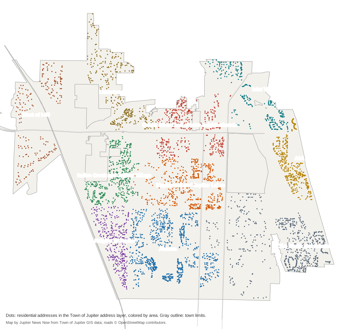
Map by Jupiter News Now from the Town of Jupiter’s GIS address, neighborhood and boundary layers; roads © OpenStreetMap contributors. The town’s own Neighborhoods Map (PDF) shows every named neighborhood and the three police patrol districts.
The west and south
Abacoa is a 2,055-acre planned community, the town says, and the largest block of homes, about 5,500, with Roger Dean Stadium, FAU’s Jupiter campus and a town center.
Heights of Jupiter and Egret Landing, about 2,200 homes, nearly all single-family, lie between Abacoa and I-95.
Indian Creek and Jupiter Village, about 2,900 homes south of Indiantown Road, are split almost evenly among houses, townhouses and condos.
West of I-95 covers Rialto, Sonoma Isles and Jupiter Country Club, about 1,300 homes beside the interstate and Turnpike interchanges.
The middle of town
Maplewood and Jupiter Lakes, about 3,200 homes between Toney Penna Drive and Indian Creek Parkway, have 11 Palm Tran Route 10 stops in or beside them.
Center Street and the charter neighborhoods take in Pine Gardens, Eastview Manor and Jupiter River Estates, which the town calls its original charter neighborhoods, around Town Hall and Jupiter High.
Limestone Creek, about 2,100 homes north of Indiantown Road, has its own elementary school.
By the water
Inlet Village is where the town began, at the Jupiter Inlet, with condos along the Riverwalk and homes on the north bank of the river.
The A1A beachfront is about 3,200 homes, three in four of them condos, between the Intracoastal and the ocean around Carlin Park.
The Bluffs and Admirals Cove, about 4,400 homes, fill the southeast corner beside the town’s dog-friendly beach.
Related guides
Property taxes, parks and trails, getting around, moving to Jupiter and Jupiter vs. Tequesta, Palm Beach Gardens and North Palm Beach.
How we built this
The areas come from the Town of Jupiter’s own sources: its neighborhoods map and the shaded neighborhood layer behind it, the Abacoa plats in its plat layer, its Neighborhood Services page (the charter neighborhoods), its Center Street page and its Community Redevelopment Plan (Inlet Village). OpenStreetMap place names (Limestone Creek, West Jupiter, North Palm Beach Heights) were checked against them. We grouped neighboring named neighborhoods into 10 areas, placing every neighborhood in the town’s shaded layer; together they hold about 92% of the residential addresses in the town’s address layer, which was last updated in 2021. Home counts, ZIP codes and school zones come from matching those addresses to the town’s neighborhood shapes and to Palm Beach County’s open data copy of the district’s attendance zones on Oct. 9, 2026.
Frequently asked questions
What are the neighborhoods of Jupiter, Florida?
The Town of Jupiter’s neighborhoods map names more than 150. Our guide groups them into 10 areas: Abacoa, the Heights of Jupiter, Indian Creek and Jupiter Village, Maplewood and Jupiter Lakes, Center Street and the charter neighborhoods, Limestone Creek, west of I-95, Inlet Village, the A1A beachfront, and the Bluffs and Admirals Cove.
What ZIP codes are in Jupiter?
The Census Bureau counts two ZIP codes with at least a tenth of their land in the town, 33458 and 33477. Some town homes are in 33469, on the north bank of the Loxahatchee River, and 33478, west of I-95.
Which Jupiter ZIP code has the highest home values?
Of the four ZIP codes with town homes, 33478 had the highest typical home value in August 2026, $882,654, according to the Zillow Home Value Index. The figure was $720,444 in 33469, $678,534 in 33477 and $623,949 in 33458.
Do Jupiter school zones follow town limits?
No. The School District of Palm Beach County draws its own zones. About 69% of the town’s homes are zoned for Jupiter High and about 31%, in Abacoa, the Heights of Jupiter and the Bluffs, for William T. Dwyer High.
Have your say